SirAndrew710
-
Posts
482 -
Joined
-
Last visited
Content Type
Profiles
Forums
Events
Everything posted by SirAndrew710
-
My guess is they consider that stop to be unimportant. Even though it’s a terminal stop, it’s only served weekends and holidays, so they must feel there’s no need for a heated shack or a BusWatch sign. In a normal week (i.e. no stats) that stop only gets 77 buses, and each stat only adds another 31. The 83 terminal at Thompson and Ness sees almost 200 a week and it only has a metal sign as well. I do wonder what an 18 extension to Charleswood would do to that route.
-
The only disadvantage I see with what they’re doing with the 83 is that it will still only have the two buses at rush hour (usually it gets a third), meaning the headways on that route will increase from 36 minutes to nearly 50 at rush hour (the usual rush hour headway on the 83 is an even 30 minutes). The 18 runs to the zoo on stats as well. I wonder why the 83 gets its rush-hour extension but the 95 and 677 do not. I do agree that the 95 should always run to at least Shaftesbury, seeing as Taylor and Grant are pretty far apart, though maybe providing a 66 connection somewhere further west wouldn’t be a bad idea.
-
406 is on the 641 today.

-
Looking at more timetables for next change, it appears they’re gonna run the 83 out to the industrial park on Saturdays. I think that’s the only deviation from the regular Saturday schedule.
-
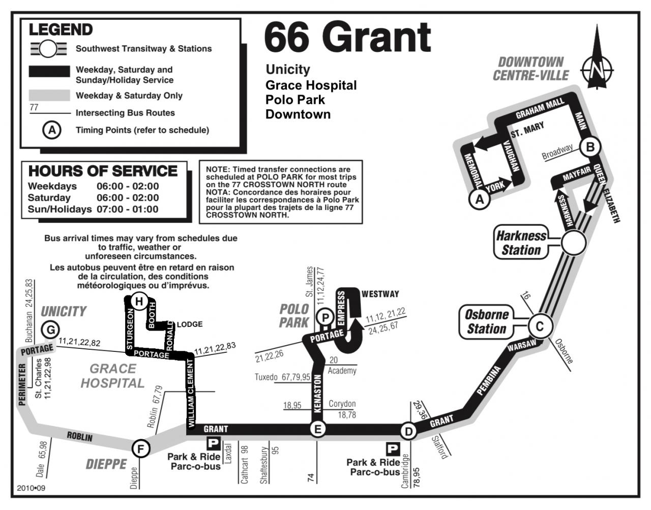
Most of the rest of the 85 is duplicated with the 44 and 90, so it would make sense. I guess this could move the Louelda branch of the 44 back onto Grey as well. If they want to go to KP from Panet, take the 77. From Concordia, take the 90. From London, take the 44. From further north, take this and transfer to the 44 or 77 at McLeod or the 90 at Concordia. Also, I drew up a new branch of the 66 which would use the Moray Bridge to access the Grace, providing additional service west of Kenaston when the Unicity branch is in operation (i.e. 10 minute headway, alternating Polo Park-Grace Hospital-Polo Park-Unicity) and replacing Dieppe Loop service when the Unicity branch isn’t (providing service to a destination of note while preserving connections with the 79 at William Clement and Roblin). And yes, I intentionally used the pre-Phase 2 map.

-
It’s a similar story with the 66. At least if you’re on the wrong one, the 24 runs between Polo and Unicity pretty regularly.
-
I figured if they’re gonna get rid of the Spirits, I may as well use the single-digit numbers to make more through-downtown routes. A while back, there was a discussion about how a possible future route coming from Gateway Road might access downtown. I later remembered seeing a city council document showing a previous version of the 44 that followed Smith/King and Donald/Princess from Higgins to Broadway, so remembering that the pre-Phase 1 62 accessed downtown via Donald, I came up with this. I named the southern segment “South Pembina” because “Richmond” is already taken by the 662 and because the St. Norbert buses don’t enter Fort Richmond or Richmond West (while there is an area of northwestern St. Norbert called “Richmond Lakes,” I don’t know how well-known that one is). Due to the sheer length of this route, I created two maps.


-
COVID-19 related article added to wiki
SirAndrew710 replied to map.man (Darrin)'s topic in UPDATES & ADDITIONS
Winnipeg Transit will adopt an enhanced Saturday schedule on weekdays effective May 4, with Saturdays and Sundays unchanged. Routes that don’t operate on Saturdays will continue to operate at rush hour only, including those that would otherwise run all day. More info: https://winnipegtransit.com/en/rider-guide/news -
From what I saw on the website, every route that runs on weekdays will continue to run. I wonder what WT means by this. How would they determine whether it “makes sense to resume regular bus service” or not?
-
Interestingly, those same posters have referred to the 183 as the “Richmond Express” as well, it having been spun off from a branch of the pre-Phase 1 62. Even though the name “Richmond West Express” appeared on the buses. I’ve also seen the 160 referred to as the “Pembina Express,” including in city council documents, even though that name isn’t entirely accurate as its express segment only lasted the length of the Transitway, though the 24 Ness Express doesn’t run express on Ness either.
-
I just noticed that there will be duplication on Roblin with both the 67 and 79 running at rush hour. Though there will only be one outbound 67 at the AM rush and two inbound 67s at the PM rush.
-
It looks like there will actually be fewer 22s, however. The last inbound one of the morning is scheduled to arrive at Whytewold at 8:09 (though all times for stops between timing points are estimates anyway), so if I’m back to work before Transit restores regular service, I’ll have to take the 21 at 8:38 when I normally take the 22 four minutes later.
-
I find it interesting to see that the the 22 will run on a regular weekday schedule (in the peak direction) but 21 will run on a regular Saturday schedule, meaning no Grace Hospital short-turns at rush hour. I guess people looking to go to Superstore or Giant Tiger will be spoiled for choice at rush hour come May 4.
-
The documents didn’t even say when those cuts would take effect. I’d assume it would be the fall seeing as that’s when the Spirits will be discontinued, but considering that their hit list included now-defunct routes, clearly they don’t even know what they’re doing.
-
If the pandemic ends between changes, would they return to normal right away? Or would I have to go to Polo and grab a 79 or go to Unicity and grab a 66 if I needed to cross the bridge for something? (Assuming the 98 is affected by the reductions, that is)
-
I agree that routes such as the BLUE line, the 11 and the 21 should be first to be reduced, but we know that practically speaking, it will be feeders and dial-a-rides that get reduced first. It makes sense, seeing as few people rode them even before COVID, but if they want to send the message that people who need to use Transit still can, getting rid of, for example, the only bus running between St. James and Charleswood (98) might not be the best idea.
-
Looks like they might go ahead and reduce service after all. https://winnipeg.ctvnews.ca/winnipeg-transit-reductions-expected-bowman-1.4905906 Of course, they refuse to say which routes would be cut and when. Bowman says that those decisions will be finalized “soon,” but they probably won’t tell us a thing until three hours before they do reduce service. My bet is it will be mostly suburban feeders that see service cuts.
-
Normally training buses have yellow run cards that say “Training Bus 55-xx” or something like that but I see that the one in the photo has a regular card (55-19).
-
Firstly, welcome to the board. Secondly, the intended purpose of this thread is basically to present and discuss completely fantastical routes, though I would be lying if I said that I wouldn’t like to see at least some of them implemented. That being said, I have created another thread for discussion of the Transit Master Plan (“What’s Next for Winnipeg Transit?”), though we’re basically sitting here twiddling our thumbs waiting for the city to release something. Speaking of the TMP, I did see that Route W, which would replace the 77 between KP and RRC, would not serve as much of the Maples as the current route. With regards to the 71, I’ve never ridden it myself but know that a lot of people take it all the way to/from Arlington & Portage, so replacing it with something might not be the best idea, seeing as my proposed 72 doesn’t run anywhere near Portage, though connections with both 19s and the 33 would be available for passengers looking to go downtown. I also know from riding the 77 that a lot of people take it between Garden City and the Maples, but those people would still have the 17. For whatever reason, the section of the 77 between Garden City and RRC doesn’t feel too long to me despite that bus going every which way through the Maples, Meadows West and Tyndall Park.
-
The 71 doesn’t serve the Maples. Are you thinking of the 17 or 77 (which have similar numbers and run into the Maples from Garden City) or 33 (runs into the Maples off McPhillips)? I drew up a map for what I had been thinking, which could possibly serve as a sister route to what I had already posted. Looking at schedules for the existing routes that serve these areas, the Maples one would be about five minutes quicker than the McPhillips one, but those schedules are impossible anyway (make every stop and you’ll run five minutes late, don’t stop at all and you’ll run five minutes early) and driving directions say that the Maples would be about three minutes longer.

-
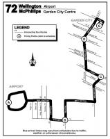
Here’s another map which I actually drew up before I came up with my idea for a Western RT Corridor and has been sitting in my photo album for three weeks waiting to be posted. I’m surprised that connections between much of the city and the airport are as poor as they are. If someone wants to travel from the northwest to the airport, the best option they have is to take the 77 to either Wellington or Sargent and switch to a 15 or 20, though that route’s 40-minute off-peak headways and limited evening and weekend service mean that’s not always an option. As such, I created this. From Garden City, it would travel straight south on McPhillips all the way to Logan, then zigzag to Wellington and follow that to the airport. The reason for the Valour-Sargent-Empress dogleg is because Wellington does not cross the CP tracks. In retrospect, it might have been a better idea to have it run through the Maples and access the airport via Keewatin, Logan or Notre Dame, Route 90 and Wellington.
-
I have noticed that the newer stops do sound different (and sometimes aren’t displayed - on the 77, one stop is announced as “Costco” but the display says “Wellington North”). What makes no sense to me is that (also on the 77) “Reenders South” is announced normally but “Reenders“ is not.
-
Last June, I was on a Spirit and the driver had to make a three-point turn to get out of the Forks because the roundabout was blocked. Seeing as the DARTs always get the D30LFs, I’d imagine that the driver would be able to do something similar. Or maybe there’s room to turn around somewhere in a nearby parking lot.
-
I pronounce it that way, though maybe I’m wrong. I don’t think there’s such signage for any RT stations, old or new. That might be because you can take the 60 just about anywhere you can take the BLUE line, but it’s a lot slower. Why did they make the stupid decision to remove express buses from Pembina Highway? Slightly unrelated, but I wonder if you can arrange for a DART drop-off at Plaza Station.
-
Of course, all these timetables are very much subject to change, with Council not likely to convene any time soon due to the virus, though what they have in store would definitely be interesting to see. With regards to funding, seeing as the provincial government ripped up the 50/50 funding agreement, I don’t see them helping out a lot.