STO_1601 Posted October 30, 2018 Report Share Posted October 30, 2018 1 hour ago, dudebrains said: Oohh! Nice pics! I like to say ''You learn something new every day!'' Well today, I learnt about STO Rollsign history! Thank you for the info! I believe they used the same Plyon rollsign that OC Transpo used. Link to comment Share on other sites More sharing options...
tomsbuspage Posted October 30, 2018 Author Report Share Posted October 30, 2018 1 hour ago, STO_1601 said: I believe they used the same Plyon rollsign that OC Transpo used. AFAIK, the Pylon signs were only used on the 88xx and 89xx MCI Classics. The GM Classics were delivered with two-digit rollsigns, but they didn't have the keypads on the dashboard. The CTCRO and later the STO started ordering digital headsigns and route markers in 1990, and the 84xx, 85xx and 86xx GM Classics had their signs replaced at the same time. The Plyon-equipped buses kept their signs for a number of years, as shown in the 1997 photo below, but those signs were eventually replaced by digital signs as well: 1997: 2002: 2 Link to comment Share on other sites More sharing options...
tomsbuspage Posted November 1, 2018 Author Report Share Posted November 1, 2018 Up for sale on eBay: a slide of a fresh-out-of-the-box Tele Transpo bus, this one being a 1973 Wayne-bodied International. The photo date in the eBay listing is 1973, and the March 1974 expiry quarterly plates bear that out. In front of 731 is a 1973 Highway Products Twin Coach TC25-TO. This slide is up for auction by "ttcbeat" and is being used for educational purposes only. 2 Link to comment Share on other sites More sharing options...
STO_1601 Posted November 2, 2018 Report Share Posted November 2, 2018 STO school bus replica from 1973 (Photo by Paul A. Bateson) 2 Link to comment Share on other sites More sharing options...
OC Transpo/STO Fan Posted November 3, 2018 Report Share Posted November 3, 2018 Found these photos today from user Photowalker4 on Flickr. These were apparently taken in May 1985, but it isn't possible with one of the photos being an 87xx GM Classic. 1 Link to comment Share on other sites More sharing options...
tomsbuspage Posted November 3, 2018 Author Report Share Posted November 3, 2018 2 minutes ago, OC Transpo/STO Fan said: Found these photos today from user Photowalker4 on Flickr. These were apparently taken in May 1985, but it isn't possible with one of the photos being an 87xx GM Classic. It looks as if the photo of 8777 was taken in 1987 as the fare in the windshield was 75c, while the photo of 8416 may indeed have been taken in 1985, as there is no fare card in the windshield. Link to comment Share on other sites More sharing options...
Oc4526 Posted November 3, 2018 Report Share Posted November 3, 2018 9 hours ago, tomsbuspage said: 8416 may indeed have been taken in 1985, as there is no fare card in the windshield. Judging by the Destination Sign on 8416 (and what appears to be a 85xx) were assigned to a Greyline Sightseeing tour. Which could explain why there's no fare card visable. Link to comment Share on other sites More sharing options...
tomsbuspage Posted November 4, 2018 Author Report Share Posted November 4, 2018 3 hours ago, Oc4526 said: Judging by the Destination Sign on 8416 (and what appears to be a 85xx) were assigned to a Greyline Sightseeing tour. Which could explain why there's no fare card visable. Grey Line contracted OC Transpo to provide the buses for sightseeing until the late 1990s, and they used 84xx GM Classics with sliding windows. However, I don't even see a slot for a fare card, which would have been behind the yellow windshield sign, and those were first installed in 1987. Link to comment Share on other sites More sharing options...
STO_1601 Posted November 8, 2018 Report Share Posted November 8, 2018 STO Brill seen in service in 1973 (Photo by Paul A. Bateson) 2 Link to comment Share on other sites More sharing options...
Bus_Medic Posted November 8, 2018 Report Share Posted November 8, 2018 50 minutes ago, STO_1601 said: STO Brill seen in service in 1973 (Photo by Paul A. Beston) That’s Paul A. Bateson. 1 2 Link to comment Share on other sites More sharing options...
tomsbuspage Posted November 12, 2018 Author Report Share Posted November 12, 2018 The following video was posted on Radio-Canada's Facebook page showing what Orleans and Rockland looked like back in 1976. I took a screenshot of the bus stop which appears in the first second of the video, showing express route 27 and regular routes 36 and 85: https://www.facebook.com/iciottawagatineau/videos/10154107078682183/ 2 Link to comment Share on other sites More sharing options...
tomsbuspage Posted November 13, 2018 Author Report Share Posted November 13, 2018 This short film titled A Bus - For Us was produced by the National Film Board in 1972 and highlighted the efforts of Beacon Hill residents to establish an express bus service in the absence of the OTC. Not only does the film show a lot of OTC buses at the beginning, but it also shows what downtown Ottawa and the Queensway were like in 1972: https://www.nfb.ca/film/bus-for-us/?fbclid=IwAR0DdpHKsOfhOJZM7Dm8uyXMzXf5zaaUclt0l0R39EvMRxIzgkCdd5_1ysU 3 1 Link to comment Share on other sites More sharing options...
STO_1601 Posted November 15, 2018 Report Share Posted November 15, 2018 STO 1966 GM New Look 6607 seen on Wellington Street in August 1974 (Photo by Paul A. Bateson) 5 Link to comment Share on other sites More sharing options...
tomsbuspage Posted November 20, 2018 Author Report Share Posted November 20, 2018 These two photos were recently posted on the Lost Ottawa Facebook page. The first shows two OTC customers waiting for their buses in front of Parliament Hill in about 1960, and the second shows a young lady waiting for her bus on Slater Street near Bronson Avenue in about 1970: 1 Link to comment Share on other sites More sharing options...
Loud-Invero Posted November 20, 2018 Report Share Posted November 20, 2018 27 minutes ago, tomsbuspage said: These two photos were recently posted on the Lost Ottawa Facebook page. The first shows two OTC customers waiting for their buses in front of Parliament Hill in about 1960, and the second shows a young lady waiting for her bus on Slater Street near Bronson Avenue in about 1970: Wow I just noticed the flagpole is one of those pointy spear ones at the top. I still see some of them around Ottawa to this day are they really that old? Link to comment Share on other sites More sharing options...
tomsbuspage Posted November 21, 2018 Author Report Share Posted November 21, 2018 2 hours ago, OCTranspoMaster said: Wow I just noticed the flagpole is one of those pointy spear ones at the top. I still see some of them around Ottawa to this day are they really that old? I think the design is that old, but it was used for many years. I don't know when OC Transpo stopped installing them, but I think new ones were still going up in the 1990s. Link to comment Share on other sites More sharing options...
Charlie Posted November 21, 2018 Report Share Posted November 21, 2018 4 hours ago, tomsbuspage said: These two photos were recently posted on the Lost Ottawa Facebook page. The first shows two OTC customers waiting for their buses in front of Parliament Hill in about 1960, and the second shows a young lady waiting for her bus on Slater Street near Bronson Avenue in about 1970: If anyone is curious, route 61 was later renunbered to 62, then 60 then 62 then the 8 then the present day 44. It roughly followed the same routing as today, but instead ended at Herongate mall. If you go really far back it was route 23 when it was first created. Link to comment Share on other sites More sharing options...
Loud-Invero Posted November 21, 2018 Report Share Posted November 21, 2018 1 hour ago, tomsbuspage said: I think the design is that old, but it was used for many years. I don't know when OC Transpo stopped installing them, but I think new ones were still going up in the 1990s. I also typically notice that they are usually associated with old 90s bus shelters. Most 90's bus shelters I've seen come with that type of flagpole Link to comment Share on other sites More sharing options...
tomsbuspage Posted November 21, 2018 Author Report Share Posted November 21, 2018 1 hour ago, Charlie said: If anyone is curious, route 61 was later renunbered to 62, then 60 then 62 then the 8 then the present day 44. It roughly followed the same routing as today, but instead ended at Herongate mall. If you go really far back it was route 23 when it was first created. Not quite. Route 62 was created in 1974 from the Alta Vista branch of route 61, but the two coexisted for years as separate routes. Route 62 became route 8 in 1984, then route 44 in 2017. Route 61 was created in 1959 as an amalgamation of the Alta Vista, Carling and Coronation routes. The Elmvale branch, which continued to operate as route 61, became a peak-period route in 1984 and was renumbered as route 45 later the same year. It became route 84 in 1989 and was cancelled in 1990. Route 60 was created in 1974 as a limited peak-period route to supplement route 62. It became route 47 in 1984 and route 82 in 1986. Route 82 was cancelled and replaced by route 41 in 2011, which became route 291 in 2017. As for "route 23", that was the Riverview Park route which began operating sometime between 1951 and 1954. Ottawa bus routes did not have numbers until 1959, so the route "number" simply told the map user which route to look up on the back of the map. Link to comment Share on other sites More sharing options...
Charlie Posted November 21, 2018 Report Share Posted November 21, 2018 7 hours ago, tomsbuspage said: Not quite. Route 62 was created in 1974 from the Alta Vista branch of route 61, but the two coexisted for years as separate routes. Route 62 became route 8 in 1984, then route 44 in 2017. Route 61 was created in 1959 as an amalgamation of the Alta Vista, Carling and Coronation routes. The Elmvale branch, which continued to operate as route 61, became a peak-period route in 1984 and was renumbered as route 45 later the same year. It became route 84 in 1989 and was cancelled in 1990. Route 60 was created in 1974 as a limited peak-period route to supplement route 62. It became route 47 in 1984 and route 82 in 1986. Route 82 was cancelled and replaced by route 41 in 2011, which became route 291 in 2017. As for "route 23", that was the Riverview Park route which began operating sometime between 1951 and 1954. Ottawa bus routes did not have numbers until 1959, so the route "number" simply told the map user which route to look up on the back of the map. Sorry, I should have been more clear. I was more referring to routes that travelled down Alta Vista Drive from downtown to about the Herongate area, not that travelled to Alta Vista. I shouldn’t have used the word “Renunbered” and should have just said that the route changed, because a lot of the times if the number changed, the routing changed. At the time of this photo, wouldn’t it have said Elmvale if it didn’t go down the Alta Vista Dr. branch? I seem to recall some buses saying Elmvale back then, but I can’t recall which ones exactly. Link to comment Share on other sites More sharing options...
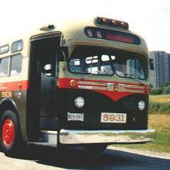
tomsbuspage Posted November 21, 2018 Author Report Share Posted November 21, 2018 5 hours ago, Charlie said: Sorry, I should have been more clear. I was more referring to routes that travelled down Alta Vista Drive from downtown to about the Herongate area, not that travelled to Alta Vista. I shouldn’t have used the word “Renunbered” and should have just said that the route changed, because a lot of the times if the number changed, the routing changed. At the time of this photo, wouldn’t it have said Elmvale if it didn’t go down the Alta Vista Dr. branch? I seem to recall some buses saying Elmvale back then, but I can’t recall which ones exactly. Yup, the sign would have said "61 ELMVALE ACRES", as shown on the rollsign of bus 5931: 2 Link to comment Share on other sites More sharing options...
Mark Walton Posted November 22, 2018 Report Share Posted November 22, 2018 On 11/3/2018 at 6:53 PM, Oc4526 said: Judging by the Destination Sign on 8416 (and what appears to be a 85xx) were assigned to a Greyline Sightseeing tour. Which could explain why there's no fare card visable. 8416-25 had windows with sliding lower sashes, except at the right-rear where it was tip-in upper sash, like 8401-15 and the 8500 and 8700 series GM Classics. On 11/8/2018 at 11:01 AM, STO_1601 said: STO Brill seen in service in 1973 (Photo by Paul A. Bateson) An ex-Montreal CD44, I never knew their Montreal numbers. On 11/13/2018 at 4:59 PM, tomsbuspage said: This short film titled A Bus - For Us was produced by the National Film Board in 1972 and highlighted the efforts of Beacon Hill residents to establish an express bus service in the absence of the OTC. Not only does the film show a lot of OTC buses at the beginning, but it also shows what downtown Ottawa and the Queensway were like in 1972: https://www.nfb.ca/film/bus-for-us/?fbclid=IwAR0DdpHKsOfhOJZM7Dm8uyXMzXf5zaaUclt0l0R39EvMRxIzgkCdd5_1ysU Colin Churcher, a local rail historian and good friend of mine, was among the promoters of that "Beacon Hill Bullet" service. He has an excellent web site on Ottawa Rail history, now hosted by the C. Robert Craig Memorial Library. That includes info on the old OER/OTC streetcars as well as the current and proposed O-Train lines. On 11/21/2018 at 7:04 AM, Charlie said: Sorry, I should have been more clear. I was more referring to routes that travelled down Alta Vista Drive from downtown to about the Herongate area, not that travelled to Alta Vista. I shouldn’t have used the word “Renunbered” and should have just said that the route changed, because a lot of the times if the number changed, the routing changed. At the time of this photo, wouldn’t it have said Elmvale if it didn’t go down the Alta Vista Dr. branch? I seem to recall some buses saying Elmvale back then, but I can’t recall which ones exactly. The Carling leg of the old 61/62 became route 65, then present-day 85. The 23 I remember was Riverside Drive-Walkley Road, which was eventually extended from Cummings Bridge to Bruyère and Sussex. In about 1975 it was folded into route 83 that ran to the airport, then rerouted from what's now North River Road to the Vanier Parkway when that opened. 1 1 Link to comment Share on other sites More sharing options...
STO_1601 Posted November 26, 2018 Report Share Posted November 26, 2018 STO GM New Look 6603 seen in Ottawa on July 9, 1973 (Photo by Paul A. Bateson) 3 Link to comment Share on other sites More sharing options...
tomsbuspage Posted December 6, 2018 Author Report Share Posted December 6, 2018 Two TBT posts from OC Transpo's Twitter account: 3 Link to comment Share on other sites More sharing options...
Oc4526 Posted December 6, 2018 Report Share Posted December 6, 2018 Found this framed image at Hillary's cleaners at Constitution Sq 1 Link to comment Share on other sites More sharing options...
Recommended Posts
Please sign in to comment
You will be able to leave a comment after signing in
Sign In Now